Premise
Yet another conflict was thrust upon me last week. I had my bikepacking rig loaded and ready to ride from home to Winnipeg, then on to St Claude and a loop through the Pembina Hills of South Central Manitoba when my phone rang with a reasonable job proposition. With a total of four paid weeks of work this year, it was impossible to say no. The bike got shoved against the wall and the tool box got loaded into the truck instead. I didn’t like the idea, but… I have to work sometime
Inspiration
I came across the idea of this ‘Poutine Ride’ from a post in the Manitoba Randonneurs Facebook group. An event described as an unoffical “Ride in the Pembina Valley” was described by some guy calling himself Vlad Perogie. The even drew some activity on FaceBook, but almost none came from active brevet riding randonneurs. In the final days before the event, I messaged Vlad with an intention to participate. He shared a Ride with GPS link for the short and long route maps. That conversation happened before the job came open. I later redrew the long map to provide better cycling computer navigation tracks. You can find the map on Ride With GPS here: Vlad Perogie Pembina Hills route.
My original plan was to ride approximately 100 km to 150 km from my home to Winnipeg the day before the event, followed by another 110 prior to the 10 am start on the morning of the ride. In hindsight, it may have been for the best that I never had a chance to attempt this schedule… but then, maybe it hadn’t been a headwind that day?
Starting off
Almost two weeks had passed since the phone rang and I aborted the original ride. I had been fifteen minutes away from departing, but without a thought, I had responded affirmatively to ‘are you available’ and even the incredulously asked ‘even tomorrow, on Saturday?’ Now, I had a couple days available. I didn’t have enough time to ride from home. It was the Wednesday before Labour Day weekend, I didn’t want to be in weekend traffic on the highway sections, but I reckoned I had enough time to ride a loop starting and ending in Winnipeg. It seemed like a reasonable compromise.
My new intention was to follow a gravel road and trail system to get from the part of Winnipeg known as the West End to St Claude, minimizing my travel on pavement. From St Claude, I would follow the Pembina Hills loop shared by Vlad, and then, I would return to Winnipeg.
On the bicycle, I carried two gps navigation devices, as well as a phone; a Samsung Galaxy S9, which had the routes also available via Ride with GPS. On the bike, I had my route to St Claude and the Pembina loop loaded as routable options in a Garmin Edge 820 bike computer as well as a Garmin eTrex 20x handheld. Both devices are mounted on my partially functioning aero bars, and both are fed from my SON hub. This trip was to be a test for this system as well.

I started riding at 9:30 am on a Wednesday morning. The route I followed out of the city took me down a cycle route on St Mathews, a portion of the Yellow Ribbon Greenway, the Assiniboine park trails, Shaftesbury and a long ride down the Harte trail. A huge pain riding the Harte trail is that it ends at the Perimeter highway. This makes for an uncomfortable and sketchy navigation across the busy roadway along with two possibly wet ditch crossings. I chose to migrate to Wilkes for this route and ride under the Perimiter highway on Wilkes, which can be a busy city highway. Around 10 am, this made for a fairly comfortable ride without too much automotive conflict.
Once across the Perimiter, the traffic intensity declined considerably. As I started moving West, I began to appreciate the full effect of the headwind I would face for the remainder of the day. The effort added was considerable, even on this paved portion of the journey. Soon, I would turn south on highway #334 towards Sanford. The added drag of tires rolling over gravel would add to the work, but initially it was offset by the turn out of the headwind. The pleasure of riding on nearly traffic free roads would make up for any extra effort, certainly?

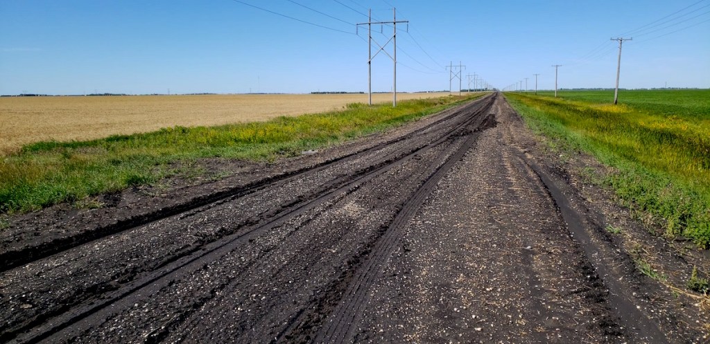
Routefinding is an activity which can only be performed to a limited degree from the comfort of an office chair, even in these days of satellite images, multiple map types and all sorts of fancy gadgetry. Initially, I had planned to migrate Westward in steps, alternating with steps down various gravel roadways. The changes in direction would provide a break in the tedium of going on for what seems an eternity with no end in sight… While plotting this initial leg to St Claude, I found it difficult to determine what roads would be passable. Many appeared to be rather questionable in nature, perhaps only made of dirt or mud. My worst fears materialized as I approached the first westerly leg meant to avoid Highway #2. The road looked like gumbo! Stopping, gritting my teeth, and riding one bicycle length confirmed my fears. My wheels plugged up, my shoes gummed up, and I turned around! This mess would have me walking for days if I chose to pursue it. I spent the next half hour and two stops trying to get enough mud out of my cleats so that I could clip in again!
The next options allowing travel Westward were equally challenging. This resulted in riding along Provincial Highway #2 for longer than I had planned. This section of highway is noticeably absent from Manitoba Randonneurs brevets. I quickly learned that it is a bicycle unfriendly section of roadway. There is alot of traffic, both automotive and heavy truck. In addition, the paved portion of the shoulder is too narrow to accomodate a bicycle.
Starbuck would be my first stop. Like most of this route, I didn’t know what I could expect to find. Rolling along into town, a Co-op gas, convenience, liquor and agricultural store came into view. It turned out to be my best and perhaps only option aside from stopping at the cafe. Just out of Starbuck, my planned route proceeded west, along what appeared to turn into a dirt road. I wondered if the route would be passable as I left town on a well packed gravel road. Momentarily, a scenic crossing of the La Salle river took my mind off the trip ahead as I took a lazy day dream float down river.

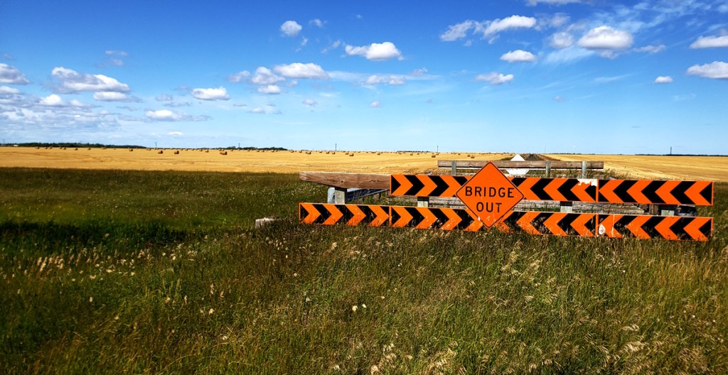
The answer to my questions regarding the roadway ahead were quickly answered positively. The road was good! In fact, the dry and relatively well packed dirt made a smooth rolling surface that seemed easier to pedal on than some of the looser gravel I had ridden. The traffic free nature of the trail was a pure joy, and the recently harvested fields littered with straw bales were a pleasant distraction from the effort of pedaling against an never ending West wind. Additionally, a regularly spaced collection of bridges which provided access to the North side of the adjacent drainage provided additional visual escape. Each was built similarly, but each was in its own unique state of disrepair. Some were passable, but the worst were missing lumber across the deck, with large orange and black barricades warning of the sudden drop off.
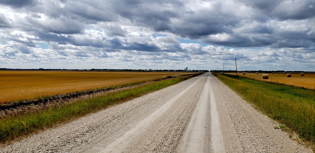
As I rode further from the city, the lengths of the straights between turns grew as well. The approach into Elm Creek provided almost a 10 km straight of dirt and gravel. There were no turns and no structure to provide shelter from the wind. An even longer straight after Elm Creek lead into Haywood. One shorter straight finished the approach into St Claude. The riding along these long straight sections grew tedious. I found myself habitually looking at my cycling computer, checking the distance I had covered. As time went by, the frequency inreased, and the elapsed intervals shrank. My progress seemed arrested in the trance of my legs spinning the pedals round and round.
Elm Creek was made noteworthy by the presence of its Co-op gas, grocery, agricultural and liquor store. It would be a convenience store if the hours were more convenient. It was open daily, from breakfast to dinner with the exception of Sundays. What made it special, was that it had fruits and vegetables, like a real grocery store! I picked up an apple that was simply delicious. On my return trip, I would pick up a pair of nectarines that were incomparably juicy and sweet. These simple treats are too often missed during gas station feed stops.
Leaving Elm Creek was a brief treat as I rode South for a mile on some sweet smooth pavement. The respite was only to be brief, as I turned West at the cemetary and continued my journey towards Haywood.
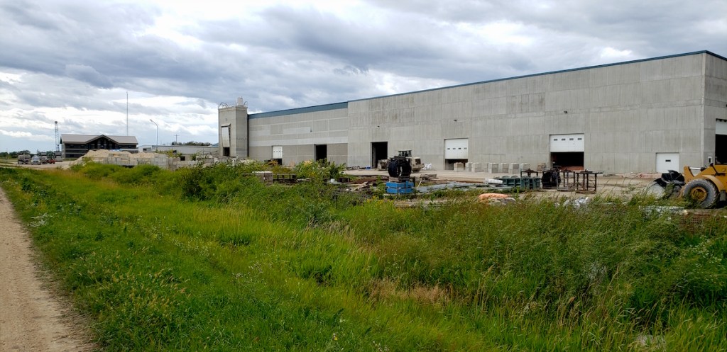
Haywood had a curious mystery for me. I had noticed a large industrial development on the Eastern edge of the town. I couldn’t determine what it was, but my route would take me immediately past it. After a fourteen kilometer ride into the wind, I came upon a large loader handling precast concrete structures. Despite a two story office structure as well as a huge shop facility, only the signs on some semi-trailer trucks identified the business as Haywood Concrete Products.
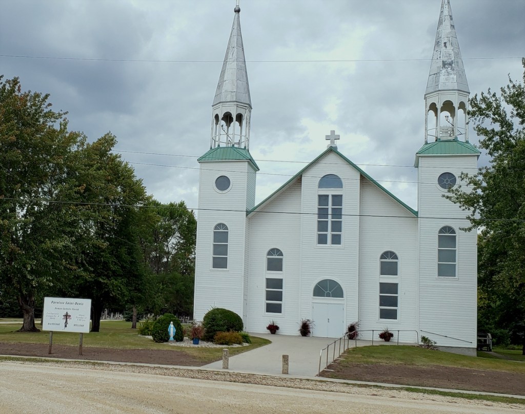
My ride through Haywood late in the afternoon allowed no stops. Only a diner whose operational status remains uncertain appeared to remain in business. The former Haywood Cafe was adorned with a closed permanently sign next to the welcoming slogans inviting truckers and all to stop and dine. I was surprised by the large cathedral like spires of a clearly viable church nestled at the North end of town. Its visual appeal was so stunning I had to divert off route to get a view and a picture.
Leaving Haywood, I knew I was undoubtedly approaching St Claude. My ride to the start of this trip had taken much longer and required more effort than I’d planned on. My initial goal was lunch at Tallboys pub and grill. It was supper time as I rode into St Claude under the most ominous sky I had in ages! Riding through town proved to be the most interesting experience of the day so far. I first encountered the Dairy Museum of Manitoba. Next door to it was a charming municipal campground and the local curling rink. By far, St Claude was the largest town along the way. There was a full service grocery store downtown and even a Chinese restaurant.

Dinner was excellent. Mid ride it didn’t take long to settle on a fettucinni alfredo dish with a chicken breast mixed in. The dinner was excellent, and the very accomodating waitress even filled my over sized 1.5l nalgene with water.
The Poutine ride proper
After a lip smacking belly popping dinner, I started off on the actual ride with some fatigue built into my legs. All that wind and those ominous skies had to foretell something right? The rain drops began as soon as I mounted my trusty bicycle, they suggested my fortune would include rain…
To be continued…
